


Corridor Restoration Project
Improving the environmental health of Oxley Creek is key to creating a legacy for Brisbane’s natural environment. Progressive improvements to habitat, vegetation and waterway health will create an environment for the community to enjoy and appreciate.
A history of exploitation and declining health
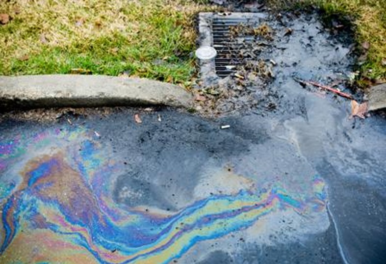
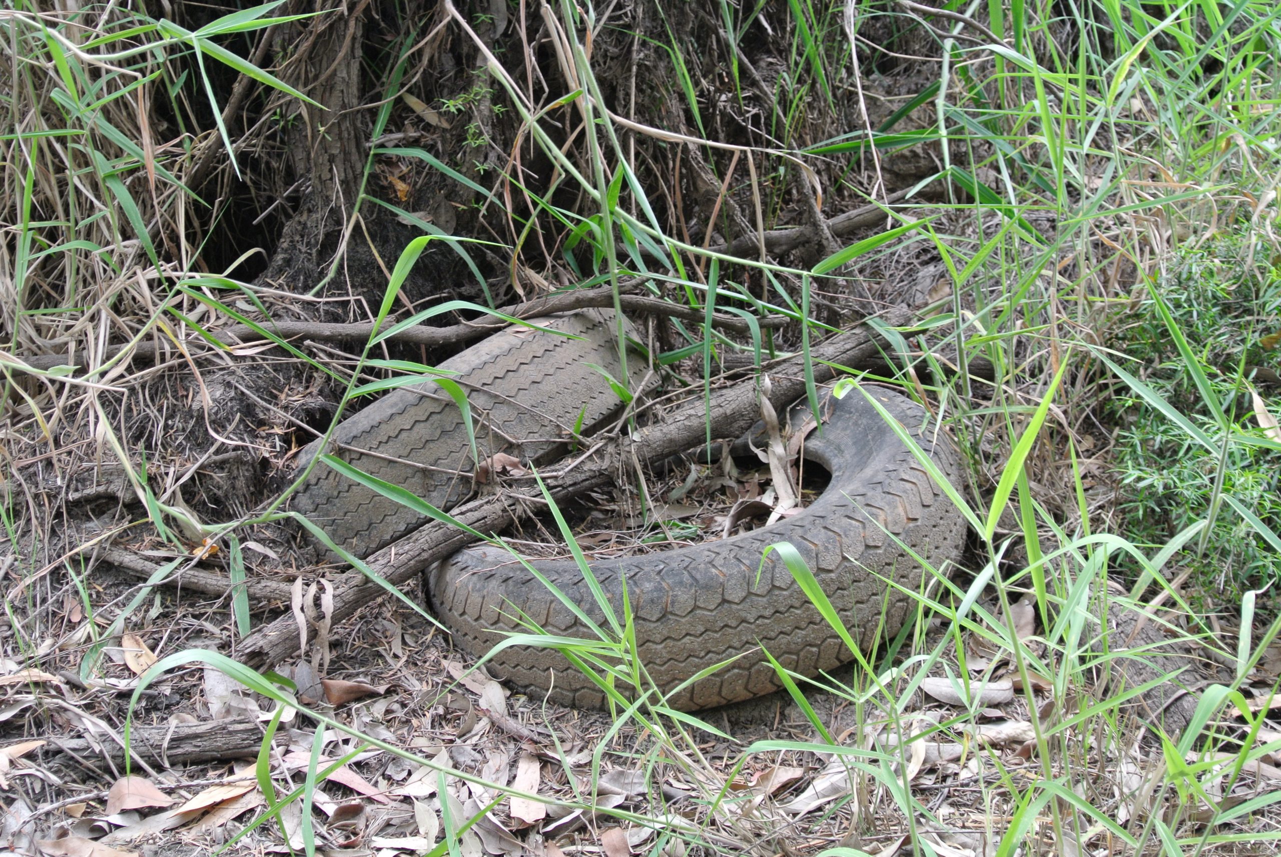
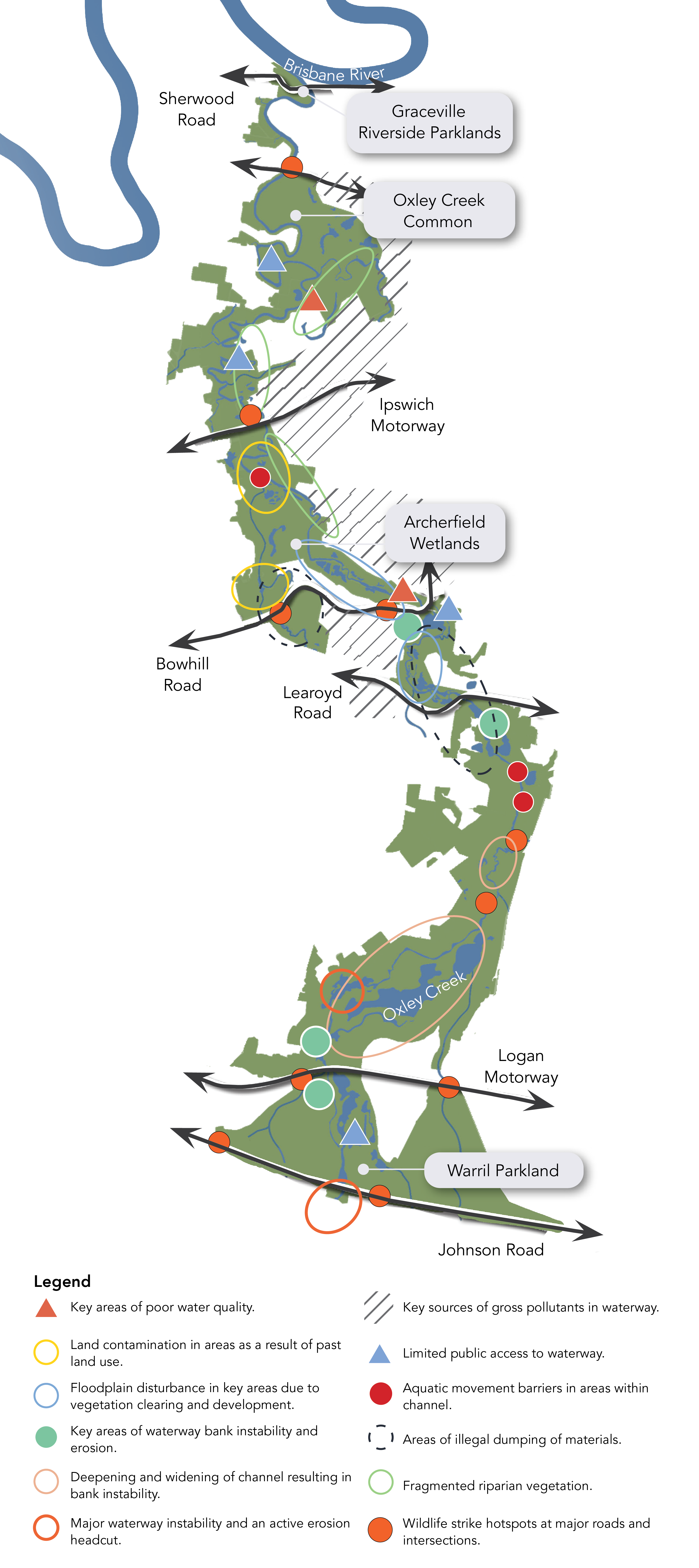
The middle and lower catchments of Oxley Creek have endured a long history of ecologically detrimental land uses, including agriculture, industry, residential development, extractive mining, unregulated landfilling activities, illegal dumping and wastewater treatment. Historically, urban development and natural resource extraction within the catchment and corridor was prioritised above natural function. These legacy land uses have affected the health of the creek in a range of ways, including bank erosion, poor water quality, soil and groundwater contamination, and disturbed aquatic and terrestrial habitats.
Oxley Creek Transformation Master Plan Corridor Restoration
Oxley Creek is the Brisbane River’s longest tributary and has the largest catchment of any creek within the city. When it reaches the Brisbane River it has passed through Logan, Ipswich and Brisbane local government areas. The Oxley Creek is also one of our most urbanised and polluted waterways. The creek and its surrounds have endured a long history of agriculture, extractive mining, industrial uses, unregulated landfilling activities, illegal dumping and wastewater treatment operations. This has resulted in significant impacts on environmental quality and health. Despite these issues, Oxley Creek’s lower and middle catchment, from Johnson Road to the Brisbane River, still holds high environmental value.
Improving the environmental health of the highly urbanised Oxley Creek corridor is critical to achieving the vision for Oxley Creek. Key environmental restorative actions identified in the Master Plan include:
- waterway and bushland restoration
- re-establishment of national, state and citywide significant vegetation
- re-establishment of natural habitat and habitat connections
- contaminated land rehabilitation works
- stormwater management and treatment
- planning for ongoing maintenance of improved land
- baselines and review points for measuring progress.
Existing condition
Over the past decades, the Oxley Creek corridor has been highly impacted by urbanisation, including past land uses such as sand mining, farming, rural and industrial development, as well as current industrial, residential and commercial development.
The impacts of urbanisation along the creek corridor has resulted in vegetation loss, channel modifications and increases to stormwater volumes and contaminant sources which have all contributed to:
- destabilisation of the creek channel
- increases in sediment erosion (during normal and weather event conditions)
- altering of the creek’s flow dynamics
- destruction and degradation of habitat and loss of habitat connectivity
- loss of biodiversity
- increases in microclimate temperatures
- reduced water quality and its ability to support life
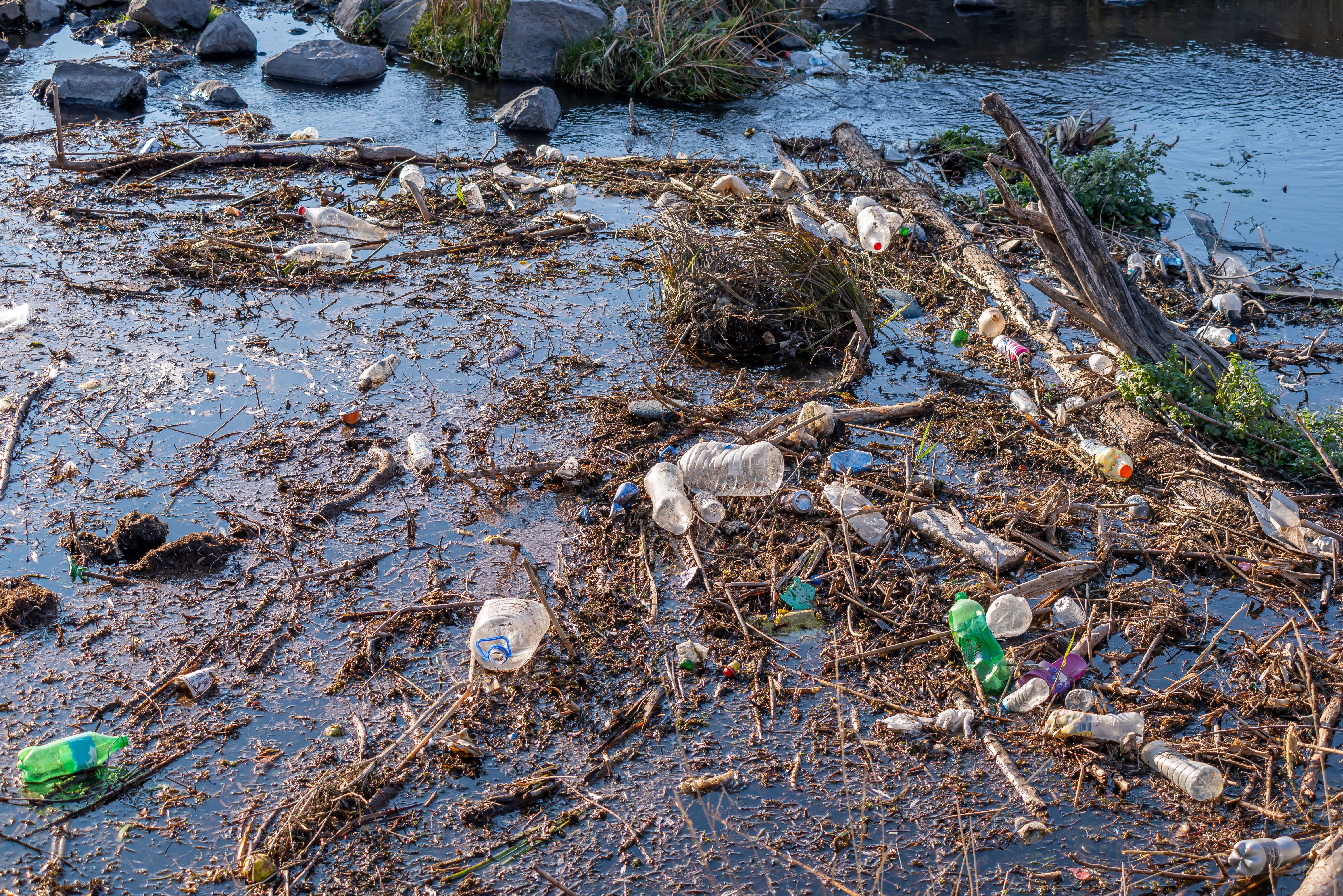
- increased prevalence of aquatic and terrestrial (surface and buried) rubbish and contaminants.
Our vision for corridor restoration
“Regenerate Oxley Creek into a biodiverse ecological corridor“
Waterway
Enhancing the functioning of the creek
‘A clean, resilient, adaptable waterway system’
Community
Connecting the community to the creek
‘A landscape for recreation and stewardship’
Nature
Protecting and enhancing nature
‘A healthy biodiverse corridor ecosystem’
Corridor Restoration approach
Corridor restoration efforts must recognise the influence that existing and proposed urban development has on the Oxley Creek corridor and, where possible, educate and partner with surrounding landowners to help minimise the impact of these land uses. Partnerships will play an important role in fostering a sense of ownership and stewardship of the Oxley Creek corridor within the Oxley Creek Transformation project area.
Restoration projects will seek to preserve and connect higher value ecosystems rather than attempt to restore environmentally degraded areas in isolation. Replicating fully functioning ecosystems in more degraded and / or urbanised areas within the Oxley Creek catchment and corridor can be complex and expensive, and can produce a poor outcome as a result of the level of change that has occurred. However, modified habitats can still be created which minimise edge effects and support wildlife habitat and movement.
Restoration work will be iterative and adaptive. Projects will be prioritised according to need, benefit and effectiveness. Projects that are feasible and achievable will be prioritised, as well as projects that have multiple benefits. Key considerations include:
- land contamination and flooding issues
- land ownership and access issues
- costs and benefits to ensure value for money
- needs and impacts of surrounding land uses, such as industry and emerging communities
- opportunities to balance recreation and nature
- management and maintenance requirements.
Restoration goals
Restoration goals have been identified to guide the direction for the delivery of the Oxley Creek corridor restoration efforts
Social Value – to create a waterway corridor network that is valued and well used by the community.
Vegetation cover -To create quality, self-sustaining and well-connected vegetation cover that contributes to biodiversity resilience, a reduction in heat island effects and improved liveability.
Riparian vegetation corridor – To maintain and enhance quality, self-sustaining and resilient vegetated riparian corridors to support increased biodiversity and wildlife.
Wildlife habitat – To create connected wildlife corridors that support terrestrial movement and habitat.
Water quality – Improve water quality to assist in providing a waterway system that supports a diverse, species-rich aquatic ecosystem.
Hydrology -Improve creek flow, bank stability, flood resilience and storage capacity.
Erosion and sediment – Reduce channel erosion and limit movement of sediment downstream.
Groundwater availability – Improve groundwater recharge and availability to provide consistent channel flow, reduce flood risk and protect and enhance existing groundwater dependent ecosystems.
Aquatic life and habitat – To create a self-sustaining instream habitat that supports a diverse, species-rich aquatic ecosystem.
Corridor Restoration Project Types
- Community focused projects – Increasing the community value and perception of the Oxley Creek corridor
- Education, research and stewardship projects – Focused on educating local businesses, residents and visitors on the value of the Oxley Creek corridor as an important environmental asset, thereby encouraging stewardship and behavioural change
- Vegetation improvement projects – To increase the canopy and density of trees within the corridor, which will improve biodiversity, the health of the waterway and human comfort within the recreational areas by providing shade as well as reducing the heat island effect
- Fauna habitat and connectivity projects – Monitoring changes to the abundance and diversity of specific fauna within Oxley Creek Transformation priority project areas as projects progress, and removing man-made wildlife movement barriers within the corridor, allowing animals to move, breed and access food.
- Water quality, flows and channel form/stability projects – Improving water quality and hydrology within Oxley Creek to support a diverse aquatic ecosystem within the creek corridor and reduce sediment and nutrient loads from entering the Brisbane River and Moreton Bay.
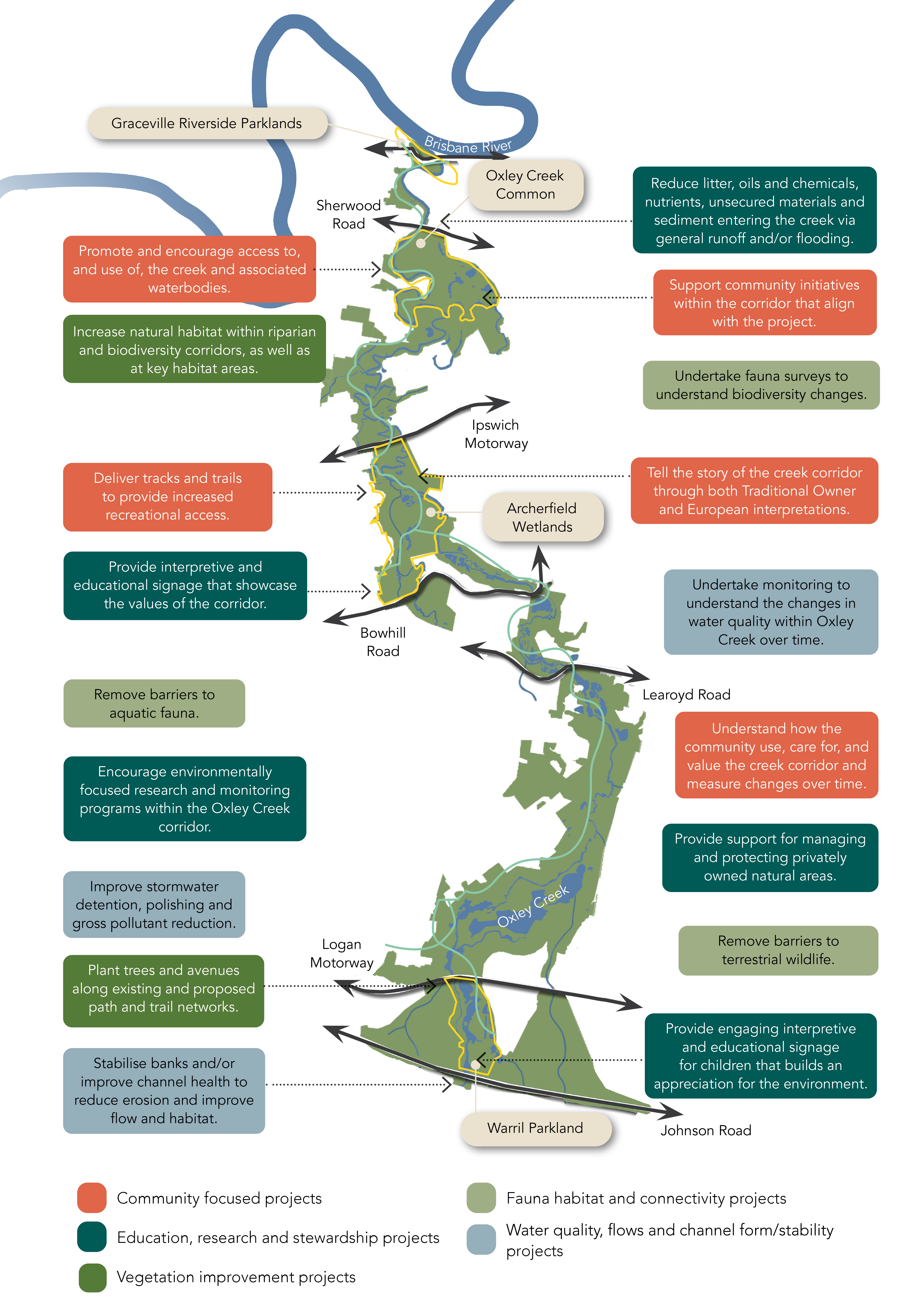
Corridor Restoration – Progress to Date
Progress on various corridor restoration projects is provided below.
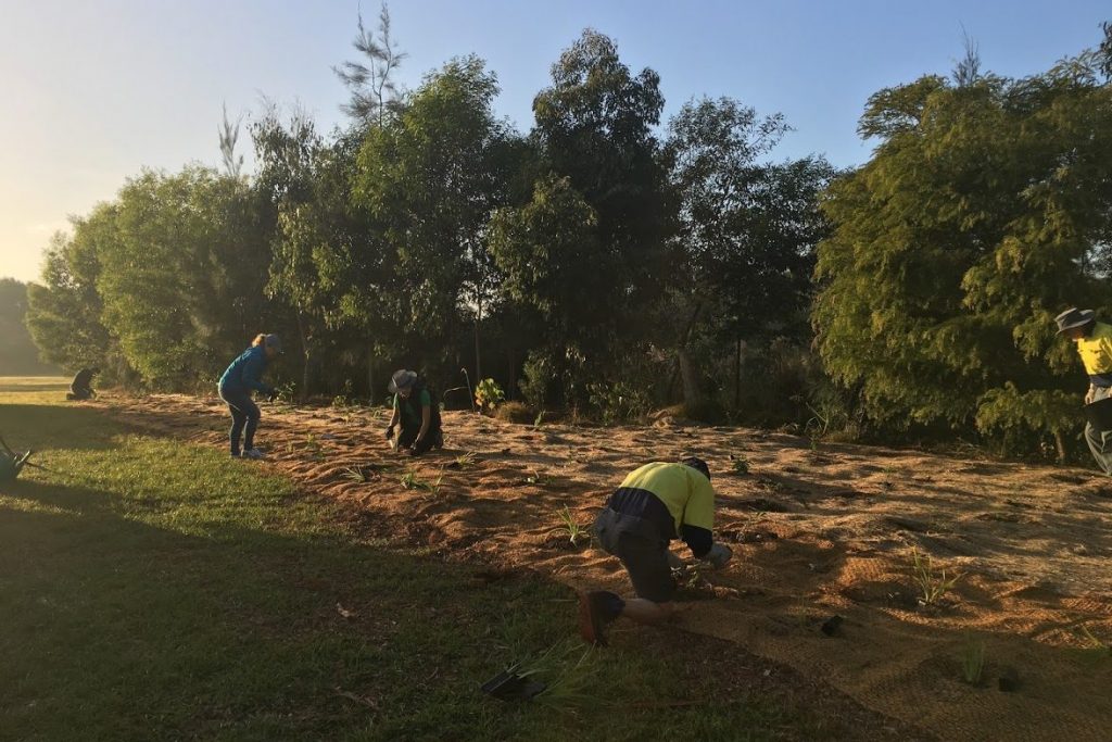
Restoring the corridor
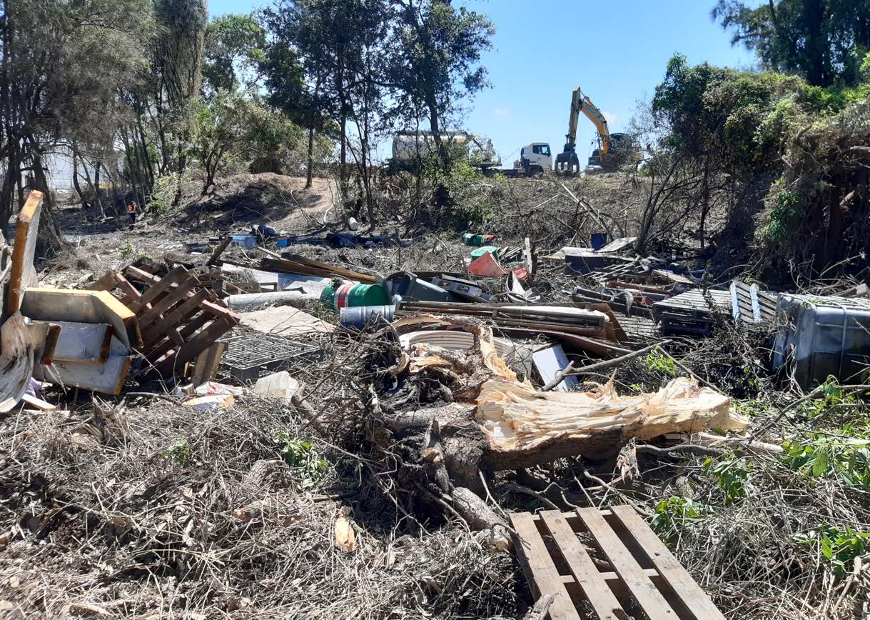
Brisbane Sustainability Agency are proud to be supporting Oxley Creek Catchment Association’s Litter and Marine Debris Project. The project involves four clean up events spaced six months apart over 2022 and early 2023. The events focus on the removal of litter and debris from Oxley Creek and surrounding green spaces. This project received funding support from the Queensland Government’s Community Sustainability Action grant program.
We are also currently investigating methods to capture litter within Oxley Creek and its tributaries, more information on this project to come.
Annual Social Survey
The Oxley Creek Social Values Survey has been developed to understand the value that the local community and visitors place on the waterways and surrounding green open spaces within the Oxley Creek corridor. Since 2021, the Social Values Survey has occurred annually to provide an ongoing understanding of how people use and value the Oxley Creek corridor over time.
The 2023 survey was open to the public for responses from 16 September 2023 to 26 November 2023 and received 577 responses.
Click here to learn more about the Oxley Creek Social Values Survey
Understanding Biodiversity
Brisbane Sustainability Agency is undertaking seasonal bird surveys at Archerfield Wetlands to assist in understanding changes in faunal biodiversity as a result of improvements proposed and delivered under the Archerfield Wetlands Precinct Plan. Birds are good indicator species which can be used to measure the health of a site as well as the efficacy of regeneration initiatives. Abundance and diversity of bird species can also be recorded through citizen science, promoting public stewardship.
We are working with Birds Queensland and Birds Southern Queensland who are undertaking the surveys within the Archerfield Wetlands project site for an initial period of three years. A total of 15 bird surveys will be conducted over this time. The surveys are being undertaken using a consistent methodology developed in conjunction with Professor Hugh Possingham, Chief Scientist, Department of Environment and Science Queensland.
Measuring Water Quality
Since March 2020, Brisbane Sustainability Agency has been undertaking monthly water quality sampling of Oxley Creek at four locations along Oxley Creek to gain an understanding of the presence of microbial contamination at key points within Oxley Creek. The presence of microbial contamination within the creek can vary and typically increases after heavy rainfall. High levels of microbial contamination can present risks to human health. This water quality monitoring program will be ongoing and will be used in the future to provide the public with more detailed and timely information on the day-to-day ability of users to participate in recreation activities on the water.
We are also working towards identifying key contributors to the poor water quality along Oxley Creek, more information on this project to come.
Improving Water Quality
Litter Trap Investigations
Brisbane Sustainability Agency has been working with Brisbane City Council to investigate the strategic placement of floating Litter Traps in high litter generating areas within the Oxley Creek catchment.
A site on Stable Swamp Creek is currently being investigated the delivery of a pilot project. The litter trap is proposed to capture the floating litter and debris from the Stable Swamp Creek subcatchment. It is estimated that approximately 10% (296m3) of litter that enters Oxley Creek could be removed each year by installing this device in this location.
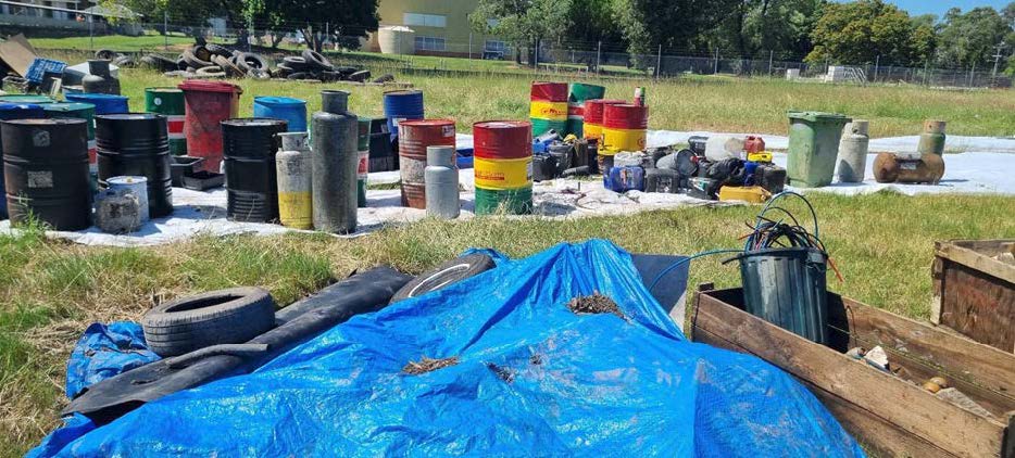
Industry and Business Engagement Program
The intention of the Industry and Business Engagement Program is to investigate opportunities to reduce litter, oils, chemicals, nutrients, unsecured materials and sediment entering the creek via general runoff and/or flooding associated with private property.
Brisbane Sustainability Agency is currently working with Brisbane City Council to develop proactive approaches to promote increased land-use and business compliance through education and targeted compliance activities.
Widening Oxley Creek’s Bushland Corridor and Increasing Vegetation
Archerfield Wetlands Revegetation
Brisbane Sustainability Agency’s Archerfield Wetlands Vegetation Management Plan uses a holistic, staged, vegetation restoration management approach that builds on the high ecological and habitat value that the parkland supports, even in its degraded state.
Acknowledging that the existing modified landscape plays a critical role in supporting a diversity of habitats, proposed restoration works will aim to:
- enhance the diverse floral and faunal habitats, rather than try to reinstate pre-European Regional Ecosystems.
- ensure restoration approaches are appropriate for the varying vegetation communities across the site.
- be undertaken in a staged manner to ensure fauna has appropriate time to transition from weed-based to native vegetation-based habitat areas.
- support the wider initiative of Oxley Creek as a wildlife movement corridor through corridor connectors, riparian and habitat planting and artificial habitat.
- create a quality nature-based recreation destination, with a particular focus on birdwatching.
The Archerfield Wetlands Vegetation Management Plan has been developed in consultation with a range of stakeholders including Oxley Creek Catchment Association and Professor Hugh Possingham.
Brisbane Sustainability Agency is currently developing Vegetation Management Plans for other key sites within the creek corridor.
Purchase of Property at 75 Bowhill Road, Willawong
Brisbane City Council’s Bushland Acquisition program have purchased the residential property at 75 Bowhill Road, Willawong. The existing house on the property has been demolished as part of its transformation into a conservation reserve, providing an increase in bushland within the creek corridor of approximately 2.1 hectares. Click here for more details on Brisbane City Council’s Bushland Acquisition program.