Tracks and Trails
Discover Oxley Creek by foot, or by bike, on one of the numerous walking and cycling tracks and trails.
Where to explore
Get active and find nature along Oxley Creek’s various walking and cycling tracks and trails. Browse the map below to find your next adventure along Oxley Creek. For more detailed information on these routes, consult the information below this map.
Click on the icon in the top left to browse Tracks and Trails.
Tracks and trails brochure
Click the link below to download a printable tracks and trails brochure
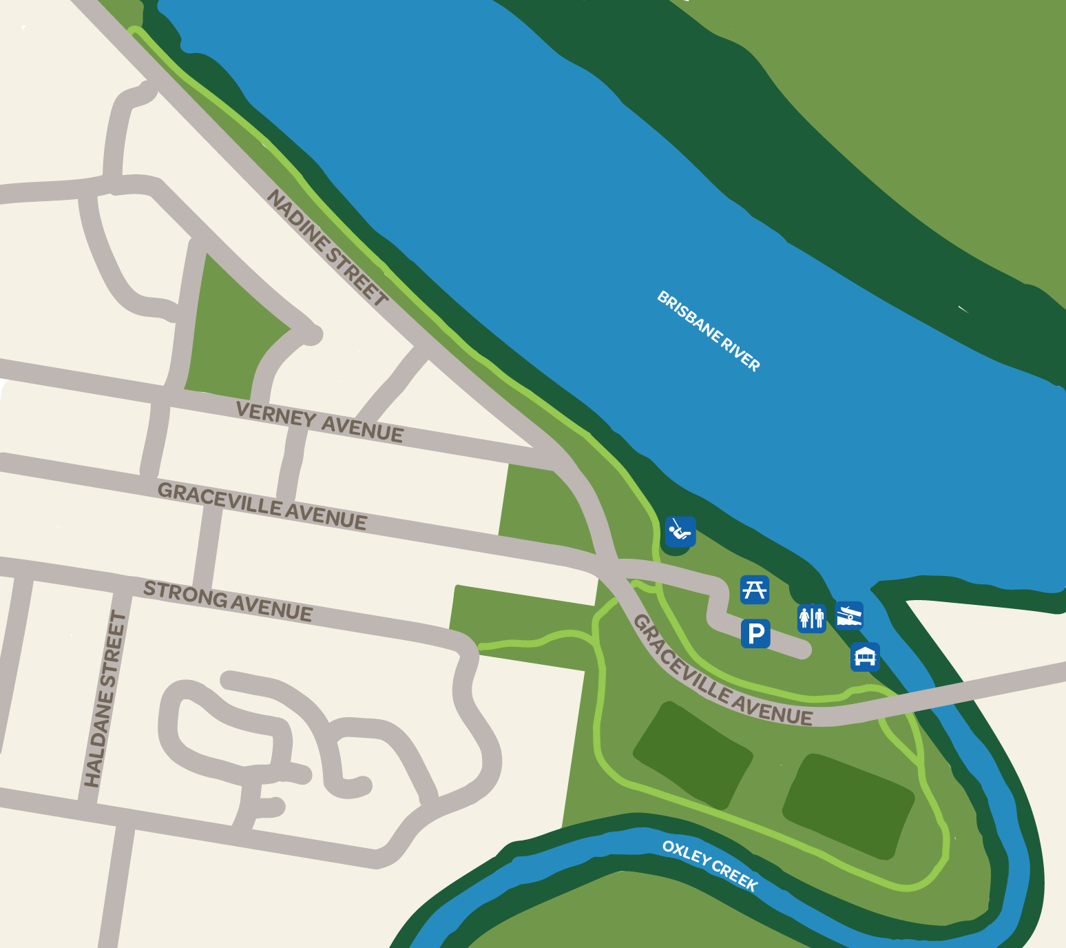
Graceville Riverside Parklands

Get active on the riverside pathway that runs between Graceville Riverside Parklands and Faulkner Park, where the Brisbane River meets Oxley Creek. This easy walk is a 2.4 km round trip.
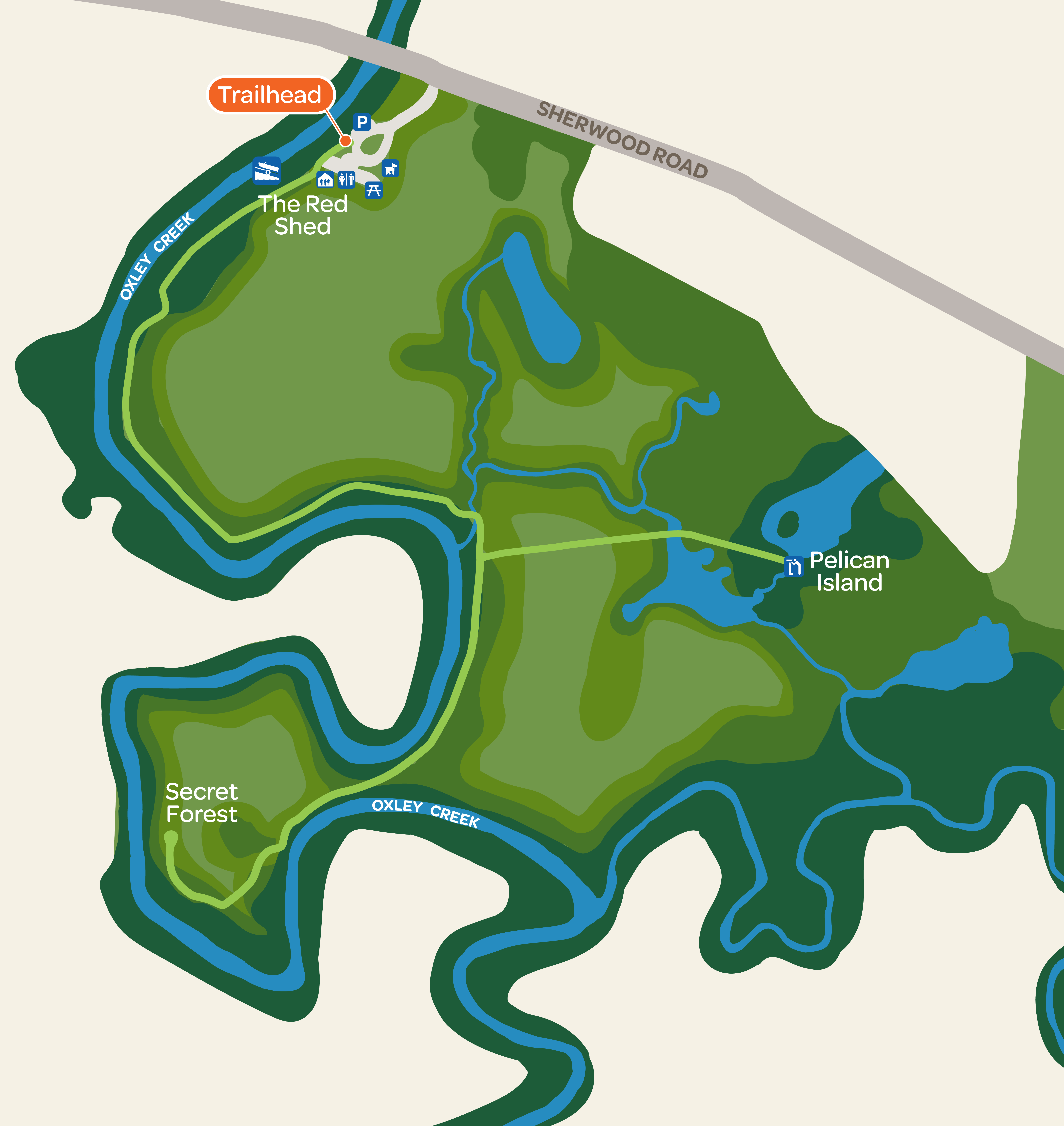
Oxley Creek Common
1. Pelican island walk
A light 3.5 km round trip from the trail head at Oxley Creek Common, ending at the Pelican Island lagoon to the south-east.
2. Secret forest walk
A low-difficulty 4.6 km round trip starting at Oxley Creek Common and extending out along the creek to the Secret Forest.
Archerfield Wetlands Parkland
1. Wetlands Discovery Trail
A low difficulty 2.9km (one way) walking or off-road cycling trail through Archerfield Wetlands Parkland. This trail takes visitors through the floodplain environment, past open grassland landscapes, Forest Red Gum bushland, over creeks and along the riparian edge of Oxley Creek.
2. Wetlands Lookout Trail
An easy, short walk (450m) accessed via the Wetlands Discovery Trail out along the edge of the wetlands, to a shady lookout point over an open water section of the wetlands.
Warril Parkland
1. Sea Eagle Lake Trail
A low difficulty 1.6 km walk or off-road cycle (one way) out to the viewing area at the northern end of Sea Eagle Lake.
2. Possum Forest Trail
An easy, short walk or off-road cycle (700 m) through bushland, starting at the playground area and ending in the car park.
3. Possum Forest Trail (via creek)
A reasonably easy, short walk or off-road cycle (750 m) with two short steep sections. This trail takes visitors along the low, creekside flats of Oxley Creek, starting at the playground area and ending in the car park.
Glider Forest
1. Dijiburr (Sugar Glider) Trail
The Dijiburr Trail (2.5km return) is the main trail within Glider Forest linking the trail network entry point at Paradise Road to the four circuit trails.
2. Ngu’dur (Paperbark) Trail
This 800m trail takes visitors to a viewing point and seating area at a small Nundare (lagoon, waterhole) surrounded by paperbark trees (Melaleuca quinquenervia). The Ngu’dur Trail links to the Wogun Trail to provide return access (500m) to the Dijiburr (main) Trail.
3. Wogun (Ironbark) Trail
The first section of this 1.5km circuit trail extends north along a ridge line and then drops down towards the Nundare (lagoon, waterhole) viewing point before turning south and reconnecting with the Dijiburr (main) Trail.
4. Gangungu (Kookaburra) Trail
This 1km circuit trail follows a ridgeline south towards Johnson Road before turing north and re-connecting with the Dijiburr (main) Trail.
5. Danduru Trail (Brush Turkey)
This 1.5km circuit traverses the south-eastern corner of Glider Forest before re-connecting with the Dijiburr (main) Trail.
Stay in the know
There are more parkland trails to come in the future. Sign up to our newsletter, or keep an eye on this page to know when new trails are opened.
Explore other destinations
Nature and Wildlife